Lake effect snow is expected to bury midwestern Ontario on Tuesday.
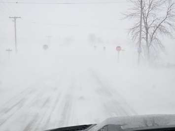
Environment Canada has the entire region under an orange-level snow squall warning with 20 to 40 centimetres of snow possible by the end of the day. Under the bands, snowfall will be heavy, significantly reducing visibility.
"Latest computer models suggest the strongest snow squall will come in off Lake Huron between Tiverton and Goderich and may extend well inland as far as Harriston to Stratford," the national weather agency stated. "Peak snowfall rates of 5 centimetres per hour are possible. If this snow squall can lock in for a few hours, local snowfall amounts may exceed 40 centimetres."
Adding to the trouble will be strong westerly to northwesterly winds gusting 70 to 80 kilometres an hour. This will cause extensive blowing snow.
"Travel will likely be extremely hazardous. Visibility will likely be suddenly reduced to near zero at times. Road closures are possible," Environment Canada said.
Drivers are advised to be prepared for quickly changing and deteriorating road conditions.
"Leave enough time, room, and distance between you and other vehicles," said West Region OPP Sgt. Ed Sanchuk. "Take your foot off that gas pedal. Clear off your entire vehicle of all ice and snow because if you can't see it, how can you avoid it? Get to where you are going, but more importantly, get home safe to your families."
Bruce and Grey counties have both declared a significant weather event. This means it may take longer than usual to bring road conditions back to a state of repair. The nasty conditions have already led OPP to close Highway 21 between Port Elgin and Kincardine.
Conditions are expected to slowly improve as squalls weaken late Tuesday afternoon.