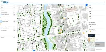
The City of Owen Sound has unveiled a brand-new Geographic Information System (GIS) web application, now accessible to the public through the City’s official website. This interactive tool is designed to provide residents with easy, visual access to a wide range of city services and infrastructure information.
The web-based GIS map features numerous data layers that users can explore and combine to suit their interests. From zoning bylaws and planning applications to park locations, tree inventories, transit routes, and waste collection schedules, the system allows residents to navigate important city information through a dynamic, map-based interface.
“This new public-facing GIS map is a practical tool for residents to better understand and navigate their city,” said Mayor Ian Boddy. “Instead of searching through multiple pages or documents, residents can now view detailed, up-to-date information visually on a map, making it easier to find what they need quickly and confidently.”
The map currently includes features such as interactive heritage plaque locations, Grey Sauble Conservation Authority regulation lands, transit stops, and more. Though primarily designed for desktop and laptop use, the City plans to improve mobile responsiveness in future updates.
The City’s GIS program features over 200 layers of spatial data and a detailed individual tree inventory of more than 20,000 trees on City boulevards and in active park areas.
Residents can find the new GIS map via a featured link on the City of Owen Sound homepage and are encouraged to watch for future tutorials and updates on the City’s website and social media channels.